Detailed program - June 22It is possible to attend on line (registration required) 08:30-09:15 It's about time... to observe surface dynamics in 4D point cloudsKatharina Anders 3DGeo Research Group, Institute of Geography, Heidelberg University Near-continuous time series of point clouds are becoming increasingly available for the observation of surface dynamics in natural landscapes. With these enormous 4D datasets (3D + time), challenges arise for (automatic) analysis, as the timing, duration, and magnitude of changes are often highly variable, and surface activities coincide or overlap in landscape dynamics. The talk features different use cases of 4D observation and puts forward approaches to incorporate the full temporal information in change analysis for the extraction and characterization of surface activity.
09:15-10:00 Presentation of the CloudCompare project and its latest developmentsDaniel Girardeau-Montaut CloudCompare project CloudCompare is an open source software for visualizing and processing point clouds and other 3D entities. We will present the project, its history, its main applications, with a highlight on the newest features introduced in the 2.12 version.
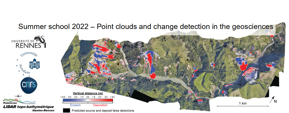
10:15-11:00 Measuring Change at the Earth’s Surface with Topographic DifferencingChelsea Scott Arizona State University In this presentation, I will discuss the methodology and applications of vertical and 3D differencing of high resolution topography. Topographic differencing measures landscape change from river erosion, urban growth, coastal processes, earthquakes, volcanic eruptions, and landslides among other events. Vertical differencing is the raster subtraction of multi-temporal topographic data. 3D differencing resolves horizontal and vertical displacements by registering topographic point clouds with a rigid deformation. I will discuss OpenTopography’s (https://opentopography.org) implementation of on-demand topographic differencing and specifically the standardization of the differencing workflow. I will show applications of differencing including fault creep rates along the Central San Andreas fault and state-wide topographic differencing applied to Indiana.
11:00-11:45 Antonio AbellanAntonio Abellan crealp Antonio Abellan is the director of the Research Center on the Alpine Environment (CREALP) in Valais. Prior to his current role, he was involved in several academic positions in world leading universities, including an assistant professorship in Engineering Geology & Geohazars in the UK (University of Leeds), a research fellow position at the Scott Polar Research Institute (University of Cambridge), a post-doc at the Risk Analysis Group (University of Lausanne), adjunct assistant professorship in the department of Geological Sciences and Geological Engineering (Queens University) and guest professorship at Eichstätt University.
13:15-14:00 Glacier mass change observations with remote sensing
Fanny Brun Univ. Grenoble Alpes, CNRS, IRD, Grenoble INP, IGE, Grenoble, France
14:00-14:30 Deep learning based 3D point clouds change detection: an application to cliffs dynamicsIris de Gélis Magellium, F-31000, Toulouse, France IRISA UMR 6074, Université Bretagne Sud, F-56000 Vannes, France CNES
14:45-15:30 Estimating dense 3D displacement vector fields for point cloud-based landslide monitoringZan Gojcic Nvidia
15:30-16:15 Point clouds in teaching: resources and strategiesBeth Pratt-Sitaula UNAVCO Beth Pratt-Sitaula is a Science Education Project Manager for UNAVCO, Research Associate at Central Washington University (CWU), and Academic Director for SIT’s Nepal: Geoscience in the Himalaya. She has extensive experience with geoscience and geohazard education. With UNAVCO she is the project manager for GEodesy Tools for Societal Issues project. With CWU, she has been a PI on Cascadia EarthScope Earthquake and Tsunami Education Program (CEETEP) and EarthScope Alaska Native Geoscience Learning Experience (ANGLE).
|


